› Forums › Forums › GENERAL DISCUSSION › DOVER DRAG STRIP GONE /complete photos Then & Now
 gaspumpchas
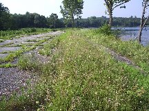
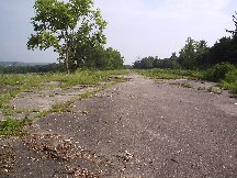
I was fortunate last summer to go to the old strip and take some pics. I’ll post them if I can figure out how (I know points and carbs, not silly computers!). I was surprised how much of the strip was still there, considering everyone told me it was long gone; we clocked a little over a quarter mile, so much of it was still there. hard to remember where everything was since the topography has changed so much due to extensive peat moss mining. Well, I found out this week that the pavement has been torn up; what was left of the strip is now history. Glad I got a couple of hunks of asphalt from the burnout lane. While walking the strip you could feel a presence of what went on there and almost hear the engines roar and the Chevy’s blowing up!!! Only kidding!!!
Glad I was able to get pics; let me know if you want them or where I could post em. Pics of the strip, return lane, change in the color of the asphalt shows the burn out lane pretty well.
RUN WHATCHA BRUNG
CHARLIE
AKA DJ CHARLIE CASH 😆
srt2stang725
awww man I really wanted to go check it out, do you know where it was? and can you post up those pics?
masoDoes anybody have the GPS coordinated of the site…? Then I could locate it on Google earth.
I used to live in Carmel… but that was in 1957. I was 10 years old. We lived at The Segwood Club on China Pond…. way up the hill and around the pond almost as far as the golf course.
anonymous
I used to live in Carmel… but that was in 1957. I was 10 years old. We lived at The Segwood Club on China Pond…. way up the hill and around the pond almost as far as the golf course.
dino and i google earth’d it. you can’t really tell what it is anymore…
 dino
dinoBEST WAY IS TO FIND THE big Harlem Valley State Hospital on Rt.22…kind of scrool up(north) to intersection…go left and follow road west about 2 miles…problem is theres nothing left but graded land.
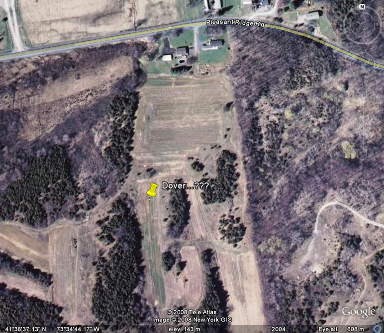
dinoCharlie …hows THIS…contacted Brian and he has an original Airial photo, 30×30 of the track back then…got it from the state survey office (This guy is amazing!) He’s going to take photo of it and send to me …We then will load into our graphics program,clean it up and LABLE things.(Roads, landmarks,etc.) I then will DRAW up an illustration of how it looked “bird’s eye view” this has never been done . Heres how to find Track Location NOW: Just north of the big Hospital on Rt.22,Wingdale, is a light (Intersection).Thats Pleasant Ridge Rd. take that west …you’ll go down a hill ,over the tracks and continue til you see First Student Bus Co. on the right .Their entrance is actually the original entrance to the the track ….going straight on that would take you to the “PitPass” booth.You’de sign in there and go straight some more to the Tech Lanes (Thats where the Bus Co. is now ).All the pits and track were to the left of that .Only remaining pavement left is about 150 ft. of shutdown area starting at the finish line and the return road. Theres two out buildings still theer in the front with a couple of rusting dozers (who knows -maybe Chet & Joes originals) In those days If you were a spectator ,you’de pay at the gate and turn left behind those buildings and drive around to the Spectator side ,passing behind the hot car pits .
masoIs this it…?
Attachments:
 srt2stang725
He said to make a right off pleasant ridge road so i dont believe so because that is left….however if i had to guess i would think this was it
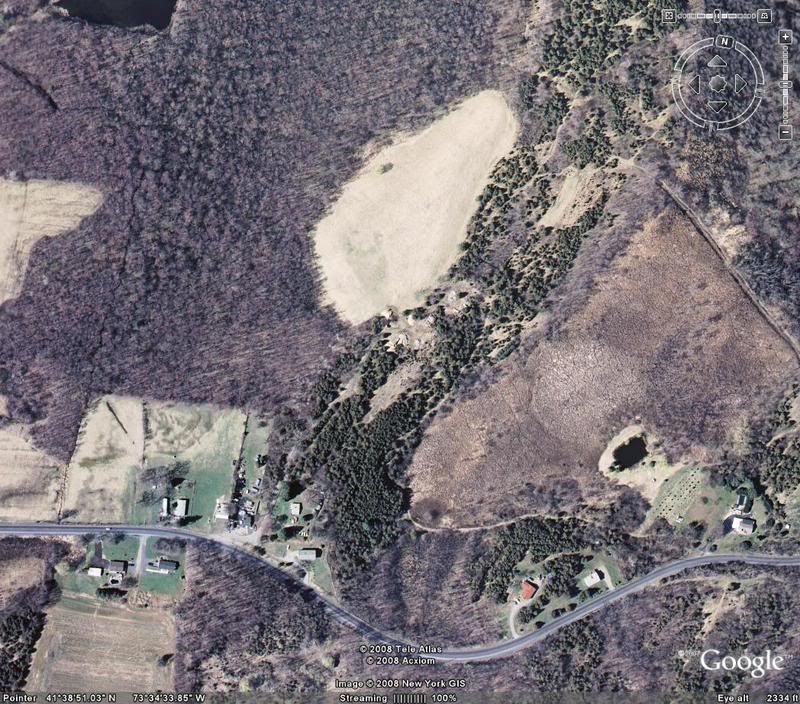
dinoOn the RIGHT going west Not Left you didn’t go far enough
masoI haven’t been there since 1965, but I seem to remember it being on the left. I remember driving by the State Hospital and crossing the tracks.
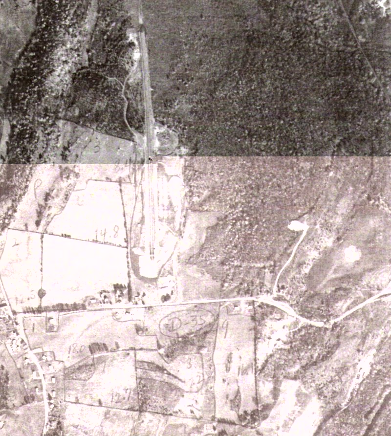
dinoBest I can do for now,,,Bad copy ,better coming THIS IS BACK THEN
Attachments:
 srt2stang725
well after looking pretty carefully at that image and then google earth this is what i came up with

dinoYES ! The long rightside road- in , goes to the Bus co. Building.
jbradleyd
I’m helping Dino here post some pic’s that Charles sent him…..
Attachments:

 hvy70ss
I was up there in 2006 and took many shots similar to these. The terrain is changed in some areas but you can easily make out some places like the starting line. I was lucky enough to get some an some shutdown area “souvenirs”!! I know I’m dreaming, but how great would it be if some of the property could be sold and the Dover Drag strip be resurrected?? Even if it was 1/8th mile like SkyView dragstrip up near Binghamton NY. Southeast NY NEEDS another track…….That Long Island deal fell on it’s face!! Oh well, I might as well buy a lottery ticket…better chance at that than a new Dover.
See ya,
Bob Smith